For Labor Day weekend, Sarah and I headed out for an epic few days in the Entiat Mountains of the Glacier Peak Wilderness. Our journey was momentarily halted by a down tree blocking the road. Luckily we're two pretty strong chicks and after a lot of grunting and lifting we were able move the massive piece of wood and continue on our way. In not time we were at the incredibly popular and scenic Phelps Creek trailhead (gateway to Spider Meadow).
 |
| A little road maintenance in route (the tree was much bigger than it looks!) |
 |
| The view of Seven Fingered Jack and Maude from the trailhead |
The trail starts pretty wide and flat as we passed dozens of families and big groups who were luckily not going our way. We had been told, that after about 4 miles you cross a creek and there's a small boot path that heads up to the right going to Leroy Creek Basin. Not wanting to miss our turn we were on the look out for any thing that might be the path. Unfortunately, there is also a nicely traveled animal track that is also just around 3.5 miles after crossing a creek. Whoops, slight detour as we headed into the bushes up the wrong trail which started to feel wrong pretty quickly and was confirmed by our gps as being about half a mile too soon. Upon seeing the real "boot trail" we felt pretty silly. There is no way you can miss this trail, there's nothing small or faint about it and Leroy Creek was a much bigger creek than the others we'd previously crossed.
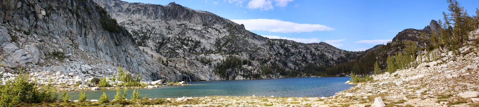
Now on the right trail we began our climb strait up. Almost 3,000 feet later we were enjoying the beauty of the basin and in search of a place to set up camp. There are several large campsites on the lower basin and even a toilet, but we decided to head into the upper basin to be closer to our next destination. We passed one group at the lower campsite and could see another setting up down below. We were quite happy with our campsite and its view of Glacier Peak and the Phelps ridge.
 |
| Leroy Creek Basin |
 |
| Seven Fingered Jack |
 |
| Our campsite in the upper basin |
 |
| Sunset and larch |
 |
| Sunset over Buck (left) and Glacier (right) |
 |
| Sunrise from the tent |
 |
| Beautiful Glacier |
 |
| Sunrise Panorama |
The next morning we were up early and off to tackle our next challenge Seven Fingered Jack. 7FJ is a jagged ridge consisting of seven finger peaks, the tallest being the one furthest north. AT 9,242 it's the 4th highest non-volcanic peak in Washington. It's a fairly straight forward scramble, no more than class III. The route is pretty straight forward. You head up to the bench at about 7,800, then cut left staying well below the cliffs. We made the mistake of heading up to steeply and close to the cliffs. Stuff starts to get a little interesting in this area. If you feel like you're doing some class IV moves, it's best to drop down a bit and gain your elevation further north. Eventually you will hit a deep narrow ravine, cross the ravine at its top and follow the climbers trail from that point to the near by summit. We made it to the summit by about 9:00 am. The views were phenomenal and we had the summit all to ourselves.
 |
| Heading to the bench to start the ascent |
 |
| We went the red route, the green route is much more mellow |
 |
| Looking down at our campsite (direct middle of shot) |
 |
| I made it! |
 |
| So did Sarah! |
 |
| Looking down at the last section of the scramble |
 |
| Glacier Peak |
 |
| Daniel, Hinnman, and Rainier |
 |
| Bonanza, such a beast of a mountain |
 |
| Fernow, this one is on the list to do soon |
 |
| Looking down the Entiat River Basin |
 |
| Huge mounds of glacial sediment |
The downclimb was much faster, now knowing the best route. We returned to our campsite, had a little rest, packed up and began our climb to Ice Lakes. From the basin you head to the obvious saddle to the south. There's a well travelled path from this saddle to the saddle above Ice Lakes. We had originally planned to bag Maude as well, but realizing that 7FJ is slightly higher and has pretty much the same views we decided to save ourselves the additional 2,000ft of scree and just enjoy our time at Ice Lakes.
 |
| There were several big trenches that we had to cross |
 |
| Looking back at 7FJ |
 |
| Maude from the Ice Lakes saddle |
 |
| Upper Ice Lake |
Once at the lakes we found a nice spot and begin to explore around. The terrain makes you feel a little like you've landed on the moon. Not much vegetation. In many places the group is made up of these golf ball sized pumice pieces that kind of feel like walking on a cloud. It was pretty awesome. We spent the rest of the afternoon relaxing and watching the occasional climber. We even saw one person ski down the basin below Maude! I can't imagine how it was worth dragging up skis for a run that lasted about 15 seconds, but then again, I'm not a skier.
 |
| Flowers at the edge of the lake |
 |
| Spectacled Buttes |
 |
| The back of the Carne Mtn High Route |
The next morning we got up and went for a walk around the lakes to further explore the area. Then it was time to check out the Carne Mtn High Route. This is a boot path that leads you just below the summits of the ridge and ends at Carne Mtn, where you reconnect with an established trail leading back to the Phelps Creek Trailhead. We'd heard mix reviews about the route finding so wanted to leave ourselves plenty of time. Our plan was to camp either at the saddle before Carne or at the summit.
The route turned out to be pretty straight forward, but involves a lot of scree. It's basically a series of bowls between saddles that you traverse, making sure to never loose too much elevation until you pass the saddle with the big knob and drop into Box Creek Basin. There was one area that got kind of cliffy and briefly perplexed us, but we were able to find an area to safely downclimb and continue. Before too long we were at the saddle before Carne and kicking ourselves for not refilling our water at Box Creek. We were pretty low and the area around Carne is dry. Camping here was not going to be an option.
 |
| Looking back at Maude |
 |
| First saddle |
 |
| Cliffy section |
 |
| That saddle is our destination |
 |
| Sarah climbing down a steep section |
 |
| The knob by Box Creek Basin |
 |
| Box Creek Basin |
 |
| Flowers and Knob |
 |
| Looking back at the route from Carne |
 |
| Carne Panorama |
We met a couple near the summit who confirmed that there was a creek along the trail below Carne, but that would mean dropping down and 1,000 ft. We decided to abandon watching the sunset from our tent on top of Carne and head down to camp near the creek. We were less impressed with the creek basin and there was already anther tent set up in the best camping spot. So after some deliberation, we decided to just refill our water and make for the switch backs back to the car. We had really wanted to spend another night in this beautiful area, but we were already so close to the trailhead and our options for campsites were pretty slim. The switchbacks felt long and grueling on our tired bodies, but were done with pretty quick. We were at the trailhead around 5pm and had plenty of time for a stop at 59er diner for celebratory burgers and shakes before making the drive back to Seattle.
 |
| Elevation Profile |
Stats for the trip:
Day 1: 6 miles, 4115ft
Day 2: 4 miles, 3,650ft
Day 3: 7.7 miles 2018ft (5733ft descent! No wonder we hurt)
Grand Total: 9,786ft in 17.7 miles