The hike starts off along an old road that heads up to an abandoned mine. Early into the hike you come upon Copper Glance creek. The original bridge has collapsed, but the boards still remain and we were able to cross without a problem. The road section of the trail was a bit grueling as it climbs about 1000 ft up to the old mine. Luckily the flowers along the trail were coming to life giving us a distraction from the constant climbing. The mine was pretty interesting although we decided not to explore into the tunnel.
At this point the road turns into an actual trail and makes a hair pin turn to the south. The climbing doesn't stop, in fact, the trail immediately after the mine was probably the steepest of the hike. Have no fear, the monotony of climbing up dusty trails is soon ended by a view of Isabella Ridge peaking over a grassy knoll. At this point it seams as if the lake should be directly in front of you, but the trail cuts to the right and continues to climb. From here on out, we no longer minded the climbing because the beauty of the open meadows filled with flowers quickly made us forget the burning in our lungs and legs. The hike became spectacular from this point onward. The flowers, the blue sky, the craggy ridge; we really couldn't have asked for more...and we hadn't even made it to the lake yet.
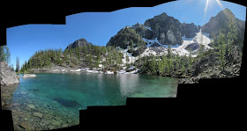
After crossing the meadows we came upon a small pond, then veered left and headed up a brief but steep gravelly slope. Soon after this you hit the highest point on the trail (again more splendid views) and then begin to drop slightly down to the lake. The lake was fantastic. The water was so clear--clearer than most lakes I've been to. The shores are rocky, but we saw a few dirt spots where you could set up a tent. The lake is also surrounded by larch which I'm sure make this a beautiful fall destination. We sat and soaked up the sun for about an hour. We watched a lot of what looked like trout swimming just below the surface. It was a pretty amazing place. On the way back we decided to scramble up another 50 ft from the trails highest point to a couple of big boulders for a 360 view of the area which I'd highly recommend.
The whole time we were out, we only passed one couple on their way down from the lake. The hike is about 6.3 miles round trip and gains about 2700 ft in elevation. To get to the trailhead from Windthrop take the Westside Chewuch Rd to the eightmile creek road and continue on this until you see the trailhead on the right.


We are taking a group of 8 (with 5 of them being teenagers) up to this area Wed-Sat (Aug 10-13). Just wanted to put that out there as fair warning for others who may want to go to the area and want more solitude on those days than 8 other people will offer.
ReplyDelete